Elevation Profiles
Another way to estimate coverage for a particular location is to utilize elevation profiles.- Go to http://wisp.heywhatsthat.com/?user=free5.
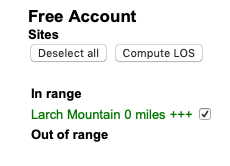
- If Larch Mountain is not listed in the Free Account Sites list in the left column (see example to the right), perform the following steps to initialize the Sites list. These steps should be only be required the first time you use the heywhatsthat Free Account.
- Download (and save) the towers.csv file.
- Click on the Towers tab in the heywhatsthat window.
- Click on Import CSV.
- Click on Browse... and select the previously saved towers.csv file.
- Click Import.
- Click on Save (to cookie).
- Click on the Map tab in the heywhatsthat window.
- Either enter the desired address into the Customer location box in the left column, or zoom in and click on the desired location on the map.
- Select Larch Mountain from the list of towers in the left column.
- Click on the Profiles tab. You should now see the elevation profile from the desired site on the left to the Larch Mountain tower on the right. The profile shows whether the terrain between the desired site and the tower will block the signal.
Copyright © 2018 Oregon HamWAN. All rights reserved.